Using Repeat Photography to Assess Climate Change Impacts
By Jim Cornett
Much has been said about how our changing climate is impacting natural landscapes. The proof, however, has been elusive. Little hard data exists about the abundance and diversity of plant life in the recent past. How can we know if plant communities have changed since the 1980s when scientists first documented that temperatures were warming and droughts were becoming more severe, particularly in the California deserts?
Some enthusiasts have asserted that desert places, such as Anza-Borrego Desert State Park, will be resilient in the face of a changing climate. After all, as one camper told me, “Desert plants and animals are well adapted to their home. A little more heat, a little more dryness won’t make a damn bit of difference.”
Is the camper correct? Will desert plants be able to cope with climate change? To find out, I tapped a previously unused source of information regarding plant life in the desert regions of California: old landscape photographs. I searched for as many historical landscape images as possible in library files and museum archives. In all, I found nearly one hundred historic pictures that showed plants and vegetation from decades past and in places that could be relocated with certainty. I then returned to those locations and took new photos. The old and new images were compared to see what, if any, differences existed. The technique is known as repeat photography and has been used before to assess landscape changes, though not in the desert regions of California.
What I discovered was surprising, sometimes shocking. Irrespective of the hardiness of desert plants, some species were not doing well. Of particular concern was the decline of our most iconic plants, including ocotillo, teddy bear cholla, and desert fan palm. For example, within Anza-Borrego Desert State Park, all but one of the historical photographs revealed significantly fewer ocotillos today. In one case, all the ocotillos were gone from the site. The situation was similar with the teddy-bear cholla. Severe declines were noted in each image. In three of the photographs, the cactus had vanished completely. Though desert fan palms rely upon upwelling fossil water along faults, recurring drought appears to have negatively impacted some palm oases. Particularly distressing was the complete cessation of palm reproduction at Seventeen Palms. Not only were there no juvenile palms to replace the old trees that would eventually die, but the adult palms have also failed to produce seeds for three successive years. Only the palm oasis in Borrego Palm Canyon appears to be faring well based on repeat photographs. This seems to be due, in part, to the Park’s management decision to steer hikers away from the stream corridor and to the periphery of the canyon. Palm seedlings now escape being trampled by throngs of people who regularly hike up the canyon.
Beyond the impacts on individual plant species, regional trends were noted. Climate change appears to have had the most severe impact in the Colorado Desert. The higher and more northerly Mojave Desert showed negative impacts, but they were less severe. There was little or no plant coverage or composition change in the still-higher Great Basin Desert to the north. It seems that plant life in the hottest and driest of the regions, the Colorado Desert, is closer to the tipping point of survival under the new climatic regimen.
I view these findings as valuable, though preliminary. The number of repeat photography sites was under one hundred, which is insufficient for rigorous statistical analysis. Hopefully, we can expand upon the findings with more scientists using this technique to assess change. Equally important, desert aficionados can contribute by examining their photographic collections and rephotographing places they have visited in the past. Such old and new photographs would be an important contribution and of keen interest to scientists.


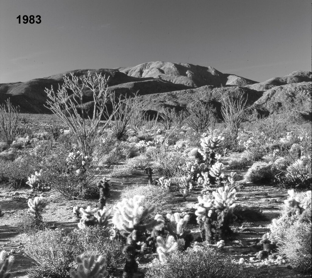
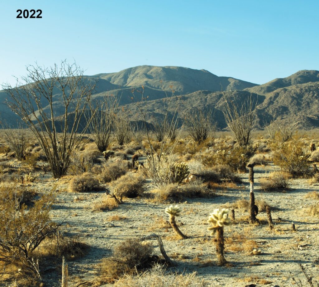
A hallmark of Anza-Borrogo Desert State Park is the rich assortment of Sonoran Desert cactus species, including teddy-bear cholla (Cylindropuntia bigelovii), Gander’s cholla (Cylindropuntia ganderi), and California barrel cacti (Ferocactus cyltndraceus). The iconic ocotillo (Fouquieria splendens) adds a striking arborescent component to the vegetation. Elevation at this site is 1,020 feet above sea level. The above photograph was taken by the author in 1983, on the bajada just south of Borrego Springs. The view is to the south.
Thirty-eight years later, in 2021, there is an unmistakable loss of ground cover, primarily because of a decrease in teddy-bear cholla and brittlebush numbers. The ocotillos persist though spreading stems on some individuals suggests water stress. As there was no indication of wildfire, direct human impacts such as off-road-vehicle use, serious invasion by non-native plant species, livestock grazing, or sheet flooding, the most likely explanation for the decline is an increase in aridity. A mean annual increase in temperature throughout the California desert region has been described earlier. Records at State Park Headquarters, six miles to the northwest, indicate mean annual precipitation declined from 6.22 inches (1948 through 1984), to 5.20 from (1985 through 2020}-a decrease of 16%. Repeat photograph site coordinates are 33°11 ‘28.0″ North, 116°21’56.7″ West (±20 feet).


